Local News
Active severe weather pattern expected across southern Saskatchewan
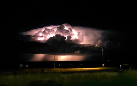
A stretch of active weather is expected across southern Saskatchewan this weekend and into early next week, with forecasters watching the potential for several rounds of thunderstorms. While exact timing and locations are still being refined, the pattern is expected to become more active late Friday night and continue through the weekend. Southern Saskatchewan and Manitoba are expected to be under a stronger southwest flow in the upper atmosphere, which can help support organized storms when heat and moisture are in place. Storms possible Saturday The first stronger round of storms could move into southern Saskatchewan late Friday night into Saturday. Forecasters say the highest risk may remain south of the border at first, but storms could still push into southern Saskatchewan. By Saturday afternoon, parts of extreme southeastern Saskatchewan could see enough heat, moisture and wind support for stronger storms to develop. Those storms could bring the risk of heavy rain, strong wind gusts, hail and frequent lightning. Larger system possible Saturday night A larger thunderstorm complex may then develop Saturday night and track across southern Saskatchewan and southern Manitoba into Sunday morning. This type of system can bring widespread rain, gusty winds and embedded thunderstorms. Heavy rainfall will be possible, especially in areas hit by stronger thunderstorms. Forecasters say parts of the northern grainbelt of Saskatchewan toward western Manitoba could see 30 to 40 millimetres of rain, with higher amounts possible in heavier storm cells. Related Stories: Severe weather risk returns Saturday across southern Prairies Another round of severe storms looms for Saskatchewan More storms possible into next week The active weather pattern is expected to continue into early next week across the eastern Prairies. Residents are encouraged to keep an eye on updated forecasts, watches and warnings, especially if travelling, camping, farming or attending outdoor events. With humidity increasing, fog may also become an issue during the overnight and early morning hours. Heat and humidity building Along with the storm risk, heat and humidity are expected to build across the region into next week. Southern Manitoba could see heat warnings later in the week as July begins. For southern Saskatchewan, the main concern through the weekend remains the potential for repeated rounds of thunderstorms, heavy rain and changing conditions over short distances.


 Sat, Jun 27, 1:00 PM


 Full-time, Permanent, Communications/Media
 Featured